Namibia Etosha National Park
Etosha National Park is one of the world’s pre-eminent wildlife areas. Etosha was proclaimed as Namibia’s first conservation area in 1907. With subsequent additions it became the largest game reserve in the world, covering a vast area of 93,240 km. For political considerations its size was progressively diminished, until by 1975 it had been reduced to its present surface area of 22,270 km. It is still one of the largest game reserves in Africa! A vast area on Namibia’s central plateau, the park’s focal point is the Etosha Pan – a flat saline desert, 130 km long by 50km at its widest in the eastern sector of the park. The Pan itself is believed to have originated over 12 million years ago as a shallow lake fed by the Kunene River. Subsequent climatic and tectonic changes have since lowered the water level so that the pan only holds water for a brief period each year – it teems with flamingos and pelicans in the summer. The saline and mineral residues together with moisture from perennial springs attract an immense number and variety of game and birds from mid March into November just before the new wet season starts. Of the 114 mammals species found in the park, several are rare and endangered, such as black rhino, cheetah and black-faced impala. The latter is endemic to north-western Namibia and south-western Angola. Etosha’s current population of more than 600 black rhino represents one of the few growing populations of black rhino in the world. Other large mammals in the park include giraffe, blue wildebeest, mountain and plains zebra, hyena and lion. Cheetah and leopard complete the trio of “big cats”. Antelope species range from kudu, gemsbok and the large and stately eland, to the diminutive Damara dik-dik. Smaller mammals include jackal, bat-eared fox, honey badger, warthog and the ubiquitous ground squirrel.
Namibia – National Parks – Maps Directions Infos: Namib Naukluft
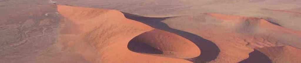
Namib Naukluft Park Namib Naukluft Park is one of Namibia’s most versatile conservation areas stretching over some 50 000 sq km with many a key features. The Namib-Naukluft Park is not only Namibia’s largest park, but one of the largest in Africa. The Namib is considered to be one of the oldest deserts in the world. It presents an ever-changing kaleidoscope of landscapes which range from the shifting dunes of the sand seas to expansive gravel plains and the scenic lagoon at Sandwich. The park can be divided into 4 areas; each of these areas has distinctive flora and fauna and offers visitors entirely different experiences and scenery.
- Sesriem & Sossusvlei
- The Namib
- The Naukluft Sandwich Harbour
(Managed as a wilderness area the Park has no large rest camps, only serviced camp sites)
Namibia – National Parks – Maps Directions Infos: Fish River Canyon
Fish River Canyon  The Fish River Canyon is situated in the far south of Namibia, almost on the border with South Africa and is part of the Ai-Ais conservation area. Ai-Ais is the name of the lower rest camp, near some hot springs at the bottom of the canyon and means “very hot” in the local Nama language.The Fish River Canyon is 160 km long, 500 m deep in places and 27 km across at its widest, it is the largest canyon system in Africa and the second largest in the world after the Grand Canyon in Colorado and is certainly one of Africa’s least-visited wonders.Although the canyon extends for 160 km, the most spectacular section is 56 km long, starting a few kilometres upstream of the northernmost viewpoint and ending at the southernmost lookout point
Viewpoints:
Several viewpoints along the western rim of the canyon afford visitors splendid vistas of the dramatic canyon. These are particularly attractive early in the morning and at sunset, when the steep cliffs are awash with colour.
The two most popular vantage points, the main viewpoint and the northernmost lookout, reveal dramatic views of Hell’s Corner, while the Sulphur Spring viewpoint, about 10 km south of the main viewpoint, and the southern most viewpoints, 12 km further on, offer visitors a different perspective of the canyon.
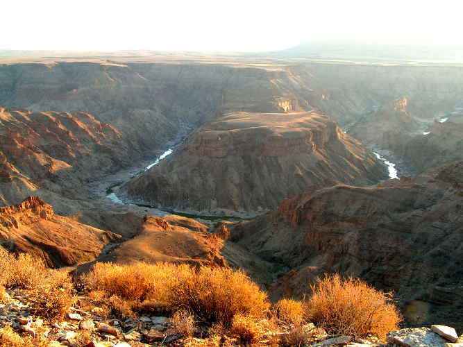 Downstream from Hell’s Corner, a few kilometres upstream of the northernmost viewpoint, the river meanders so widely that a straight-line distance of 32 km is more than doubled by the river-course. These meanders were probably incised by the mature Fish River when it flowed over the broad, level plain which today forms the floor of the upper canyon.From these viewpoints visitors can gain a clear insight into the forces which shaped the canyon.
(click image to enlarge)
DIRECTIONS:
If you’re driving from Keetmanshoop, take the B4 south-west for about 44 km before turning off left onto the C12, and then continue 77 km before taking a right and following the signs to Fish River Canyon. This final part of the approach is across undulating ridges and spectacular semi-desert plains, leaving the visitor in suspense until the very last moment about the spectacle he is about to witness.
ACCOMMODATION:
Hobas caters only for campers, and overnight facilities are limited to twelve beautifully shaded camp sites with fireplaces, a field kitchen and ablution facilities.
No pets allowed.
Canyon may be viewed at any time.
FISH RIVER CANYON HIKING:
Hiking may be undertaken from May to end of September.
Groups (3 – 40 persons maximum) wishing to undertake hiking trips must apply well in advance.
Medical certificates of physical fitness, issued within 40 days prior to hike, must be submitted at Hobas before commencing the hike.
Hikers must arrange their own transport before and after the tour.
You are advised to camp at Hobas the night before the hike begins. An indemnity form must be completed at Hobas.
Please note: No Transport is supplied to and from the starting point of the hike. TOP
Namibia – National Parks – Maps Directions Infos: Cape Cross
Cape Cross Seal Reserve The seal colony at Cape Cross is undoubtedly the main attraction on the coast between the Skeleton Coast Park and Henties Bay.The seal reserve with its surrounding area was proclaimed a reserve in 1968 to protect the biggest and best known of the 23 colonies of Cape fur Seals which breed along the coast of South Africa and Namibia. During the November / December breeding season as many as 150 000 of these animals gather at Cape Cross. It is also the area where the Portuguese navigator Diego Cao erected a stone cross in 1486.To enable visitors to appreciate the reserve more fully, a self guided drive incorporating six points of interest in the reserve has been planned. DIRECTIONS:
The turnoff to the reserve is signposted on the C34, 120km north of Swakopmund. The entrance gate is 3km beyond the turnoff and the reception area is 1km further. ACCOMMODATION:
No accommodation is available, but the reserve is easily accessible from Swakopmund, Henties Bay and camp sites in the National West Coast Recreation area. It is en route to the Skeleton Coast Park.
FACILITIES:
Amenities are limited to toilets and drinking water.
Open daily from 10h00 to 17h00.
No accommodation, only drinking water and toilets.
No pets allowed, but there are kennels at the gate.
No motor-cycles.
Namibia – National Parks – Maps Directions Infos: Skeleton Coast
Skeleton Coast National Park The Skeleton Coast Park was proclaimed in its present form in 1973 and extends from the Kunene River in the north for some 500km to the Ugab River in the south, its total area being approximately 16,400 sq km.The attraction of this remote area lies in the untouched landscapes of windswept dunes, rugged canyon walls and extensive mountain ranges. Its aura of mystery and mightiness is largely due to the dense coastal fog and cold sea breezes caused by the cold Benguela Ocean current from the Arctic, and bones scattered on its beaches from where the park’s name derives.The landscape in the park ranges from sweeping vistas of wind swept dunes to rugged canyons with walls of richly coloured volcanic rock and extensive mountain ranges. Its level coastline characterises the park, only occasionally broken by scattered rocky outcrops. The southern section consists of the gravel plains, but north of Terrace Bay high dunes occur in the immediate vicinity of the coast.The remains of shipwrecks scattered along the coast bear witness to many ships, which have come to grief along these desolate shores.The Ugab River is its southern boundary, and the park stretches north to the Kunene River. The park covers over 1.6 million hectares and divided into two zones – the southern section, between Ugab and Hoanib rivers, and the northern section – between the Hoanib and Kunene rivers. The latter has been demarcated as wilderness area and tourists can only enter the area by means of exclusive fly-in safaris conducted by a concessionaire. Of special interest are the ” Clay Castles” of the Hoarusib, the salt pans near the Agate Mountain and one of the largest seal colonies in the world at Cape Fria . 
The vegetation between the Ugab and Huab rivers falls within the Central Namib type, while that of north of the Huab is classified as Northern Namib. The vegetation is relatively spare, the most common species being dollar bush, brakspekbos and the occasional stands of ganna.Most of the plant and insect species depends for their moisture on the thick for that envelopes the coast and hinterland, and in the northern edges of the wilderness, where there are rivers of sorts as well as underground water, birds and animals manage to survive and even flourish. Mammals along the coast are mainly limited to black-backed jackal, brown hyena and the Cape fur seals. Unusual inhabitants like the coastal lion had been seen, uniquely adopted to utilize coastal resources. The lions did not inhabit the coast permanently but used the river courses that cut through the Namib to move between the coast and the interior.Far more prolific is the bird life occurring along the coast. As a result of the nutrient-rich ocean off the Skeleton Coast Park, large numbers of sea and shore birds are attracted.Adjoining the northern section of the Skeleton Coats Park is Kaokoland inhabited by the Himba people, who still live according to ancient customs and traditions and to the southern section of the park is Damaraland, inhabited by the Damara people, who have adopted western lifestyles.
ACCESSIBILITY:
The southern section of the park is accessible to the general public and attracts anglers to its superb fishing grounds. Because of the ecological sensitivity of the area, the Ministry of Environment and Tourism manages it. This park was opened for the through-travel in October 1998 and travelers must be in possession of the necessary permit which can be obtained from the Ministry’s Reservation office in Windhoek or its Information office in Swakopmund. The park can be entered at Ugabmund and Springbokwasser checkpoints.
The Northern section of the Park is a tourism concession and restricted to fly-in safaris only – (Please see our Namibia Fly-In Safari section)
DIRECTIONS:
The Park can be reached either along the C34 linking Swakopmund and Terrace Bay or from Khorixas via Springbokwasser along the C39. Traveling from the south, the Ugab River Gate is about 200 km north of Swakopmund. Torra Bay is 117 km further north, while Terrace Bay is another 48 km further on.
Approaching from the west, the gate at Springbokwasser is reached 170 km west of Khorixas. From here it is a further 40 km to the junction with the C34, with Torra Bay and Terrace Bay being 10 and 58 km north respectively.There are landing strips at Torra Bay and Terrace Bay, but no aviation fuel is available. If you fly in you should circle the camp before landing to draw the attention of camp staff that will then pick you up.
TERRACE BAY – AIR STRIP:
NOT LICENSED: 1959 S, 1302 E
Elevation: 1 00
Runway: 33/15, 1 515 m, Hard Sand
ACCOMMODATION:
Although the early mariners passing along the desolate coastline of Namibia centuries ago feared the Skeleton Coast, the park is today a popular tourist attraction. Many anglers are lured to the Skeleton Coast by its reputation for excellent catches, while other visitors are attracted by the name which evokes a sense of mystery and intrigue. For some the appeal of the Skeleton Coast is simply the solitude.
TERRACE BAY: (Terrace Bay is open throughout the year) Visitors are accommodated on an all-inclusive basis in bungalows containing two-bedded bedrooms, showers, wash basins and toilets. Bedding is provided, but as the tariff includes three meals a day, appliances such as kettles, stoves and fridges are not supplied, nor are there any outside fireplaces. FACILITIES:
Amenities at Terrace Bay include a filling station and a shop which stocks a limited range of groceries, liquor, souvenirs and bait. Ample freezing facilities are available for anglers. IMPORTANT:
No pets allowed
Overnight visitors must be in possession of reservation advices issued by the reservations office in Windhoek
No-one will be allowed to cross the Ugab River after 15h00 or to pass the checkpoint at Springbokwasser after 17h00 en route to Terrace Bay.
No motor-cycles
No camping allowed
No visitors allowed north or south of the demarcated angling area
TORRA BAY: (Torra Bay is only open from 1 December to 31 January) FACILITIES:
Facilities are limited to camp and caravan sites served by communal ablutions. A small fee is charged for the use of the showers as the water has to be transported in.At Torra Bay fuel, firewood and water are sold during the Namibian December/January school holidays only, while a kiosk is also open during this period.IMPORTANT:
Overnight visitors must be in possession of reservation advices issued by the booking office in Windhoek
No-one will be allowed to cross the Ugab River after 15h00 or to pass the checkpoint at Springbokwasser after 17h00 a route to Torra Bay
No visits to Terrace Bay without booking advices
Fuel, fire-wood and water sold during the December school holidays
No pets allowed
No motor-cycles
Visitors Travel Journal to the Skeleton Coast Park
The Skeleton Coast Park, a seemingly hostile, barren environment will allow you to experience the mystery and subtlety of nature hidden in its fragile mistiness if you take the time and utilise all your powers of observation. It is a fascinating area, with its history of rumors of “diamond rich” deposits, which lured the hopeful and proved to be illusions.
Here nothing is obvious, nothing predictable, as you travel through the apparent emptiness of the desert from the southern boundary of the park – the skull and crossbone gates at the Ugab River.On the way, you will have traversed the lichen-strewn gravel plains of the National West Coast Recreational Area from the quaint German colonial town of Swakopmund , passing the small holiday villages of Wlotzka’s Baken and Henties Bay , stopping to see the impressive breeding colony of Cape Fur Seals at Cape Cross . Here, Portuguese navigator Diego Cao planted a cross in 1486, a replica of which stands on a rocky rise near the noisily active seals.The road to the ship wreck of the Winston, one of the many fishing vessels to prove that the name Skeleton Coast is truly apt, is well signposted a few kilometers south of the gate to the park. Please note that the salt pan next to the track is treacherous; under no circumstances should you try to drive on it even in a four- wheel drive vehicle. It is well worth a visit, however, as not only the wreck but the flotsam on the beach illustrates the violence of this section of the Atlantic coastline. It has also provided a suitable nesting site for Cape Cormorants who build high seaweed structures on the masts and bows of the now skeletal vessel.The gate adorned with a skull and crossbone at the permit check point just south of the Ugab River is your first glimpse of the park. Your first stop after checking in should be the Ugab riverbed itself. Here you will be introduced to the diversity of flora and fauna present in all the riverbeds. The normally dry Ugab River, stretching almost 500 kilometres from its head waters in the interior, is one of the major Namib Rivers, all of which form life-giving arteries for the larger species of animals and vegetation to be found in the desert. You will see stunted, wind-blown Acacia trees and perhaps be lucky enough to catch a glimpse of springbok, gemsbok or even brown hyena and lion which are known to occur there periodically. The dense stands of alien wild tobacco plants, Nicotiana glauca, which are carried down with the periodic flood waters, have been removed in patches, in an experiment to determine the effect of the plants on indigenous vegetation.
Three-day Hiking Trails in the Ugab can be arranged through the Ministry of Environment & Tourism.Driving northward from the wide river bed, you will travel parallel to the sea, between lichen-covered gravel plains. In this section you will need all your powers of observation as life forms on the gravel plains are small and seemingly insignificant. The best is to stop on the side of the road and to walk onto the plains. Look down carefully and you will notice that what looked like green pebbles from the car, are, in reality, stones covered by the strange, plant-like lichens, a combination of algae and fungae, which grow in the coastal areas. In this symbiotic relationship, the algae provides nutrition through photosynthesis, while the fungae can utilize moisture.On a foggy, cool morning their colours are far more obvious, as their leaves open to make the most of the moisture available. On dry, sunny, windy afternoons, their leaves fold, presenting less of their surface area to the sun and thus preserving moisture, but also becoming less obvious. In some areas you will be able to see up to five different lichen species growing on one rock, with colours ranging from deep orange, through various shades of green to dull black.These plains are also the nesting area of the pretty black and white Damara Tern, whose eggs and chicks are so well camouflaged that you have to be very careful not to step on them. These rare and endangered birds are strictly protected but are threatened by human disturbance.The gravel plains , with their related fauna and flora are extremely fragile and the damage done to areas by vehicles driving over them indiscriminately is at once unsightly and reprehensible. Many smaller species of fauna shelter below the pebbles and are destroyed by vehicles, as are the eggs and chicks of the Damara Tern. The surface of the plains is brittle and easily compacted by wheels, with resultant tracks that last for decades. These tracks, in turn, destroy the lichens which are very slow to re-establish. Some experts believe that it could take up to a century for the substrate to recover sufficiently to allow lichens to be able to start growing again. If you do pick up a rock to study the lichens more closely, please be sure to replace it in its original position, as a changed angle could deprive the lichen of moisture and thus cause a die-off of the growth.Here you will have the chance of glimpsing the little black or white tenebrionid beetles of the Namib as they scurry between the small mounds of sand that have collected around dwarf shrubs. These little beetles and the fish moths found throughout the Namib, shelter under and feed on the wind-blown detritus that collects on these mounds, which are characteristic and can be seen around all low vegetation along the windy Skeleton Coast.
The next river you cross, the Huab, an ancient glacial river, though not as long as the Ugab, is as important for the food and shelter it provides for a variety of wildlife, including the uncommon Osprey which sometimes feeds near the river mouth.Outside the boundaries of the park, both Ugab and Huab Rivers support the southern populations of large mammals such as elephant and black rhino which have adapted to life in this unbelievably arid environment. On the northern bank of the Huab you will see barchan dunes, small, whale-shaped, “marching” dunes that are moved across the gravel plains by the wind that is an almost permanent feature of the Skeleton Coast. These dunes support the same fauna found on large dunes, but, by moving, aid the distribution of the various species of insects, lizards and rodents. Between the Huab River and the apparently insignificant Koichab River you will be able to visit another shipwreck, that of the fishing schooner Atlantic Pride. A little further on you come across a strange, rusted structure to the right of the main road. This derelict oil drilling rig was erected by hopeful entrepreneurs before the park was proclaimed and now provides a perfect nesting area for a breeding colony of Cape Cormorants. The rusty skeleton contrasts with the noisy, active birds, continuously flying in and out with fish or seaweed. The colony attracts jackals, often seen scavenging below the rig and the fearsome looking, but mild-natured brown hyena, which, as it is nocturnal and not often seen during the day, can be identified by its spoor of a large forepaw and smaller hindpaw.The Koichab River, which you may not even notice unless you are expecting it, is no less important than the other rivers for its shrubby vegetation and related fauna of rodents and insects, gemsbok, ostrich and springbok.The only other access road to and from the park is one which leads east to Khorixas, out of the Springbokwasser gate. This stretch of road takes you past a series of barchan dunes to the nearby escarpment hills, whose grey coloured caps are caused by incredibly rich lichen growth. Further east on this road you will come across the famed Welwitschia Mirabilis growing in dry river courses. This two-leafed member of the conifer family only occurs in the Namib Desert. Gradually more diverse plant species become noticeable including the tall Euphorbia damarana whose thin, stiff leaves seem to reach up to the desert sky. TOP